Hunter Falls and Hunter Creek
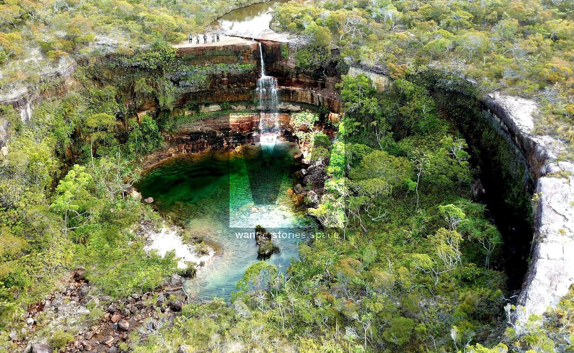
Hunter Falls is an impressive twenty metre waterfall that is located on Hunter Creek in Jardine River National Park, Cape York. The waterfall drops into a crater like waterhole which offers a magnificent swimming spot and a small, clear sandy beach for camping.


Location - Jardine River National Park, Cape York, Queensland, Australia Difficulty - Grade 6, very difficult, recommended for experienced bushwalkers
Distance - 34 km return
Time - 18 hours return
Hunter Falls is an impressive 20-metre waterfall that is located on Hunter Creek in Jardine River National Park, Cape York. The waterfall drops into a crater-like waterhole, which offers a magnificent swimming spot and a small, clear, sandy beach for camping. Note that a camping permit is required.
The hiking route retraces part of Edmund Kennedy's 13-man expedition along the east coast of Cape York in 1848. Apparently, it was a horrific expedition on many accounts. This is where Kennedy met his demise, as he was speared and killed by local aboriginals. The long journey, supply issues, and accidents, all in all, left only three of the original team surviving.
How to get there
To get to the start of the hiking track, drive approximately 15 kilometres from Captain Billy's Landing Campground back toward the Peninsula Development Road. Park your vehicle in one of the many cleared gutters on the side of the road. The track starts at approximately 11°35'41.94"S 142°45'52.09"E and heads north through thick bushland. The start of the track is hidden behind some fallen trees and is not easy to spot from the road, but you will know once you have found it as there is a distinct "No Access" sign within the first 10 metres.
The Track
The track is a very old, unused road that weaves its way through dense bushland. In places, the track is hard to follow due to thick vegetation and heavy regrowth, but look out for old chainsaw cuts, bulldozer marks, and general clearings to keep you on track. You will want to stay on the track as much as possible, as you will need to make good time in this section. The track lasts roughly 10 kilometres (just over half the distance) before it dissipates and is unfollowable. The track roughly terminates at 11°32'30.92"S 142°47'47.66"E. At this point, the following two things are extremely important:
- Ensure that you still have adequate water reserves to last another three hours of hard hiking.
- Ensure that you have at least five hours of remaining daylight.
After the track terminates, things get really difficult. You will now need to head in a northerly direction, cutting your own way through extremely thick vegetation for the remaining seven kilometres. This is hard going, and progress is slow with one-kilometre gains taking up to one hour.
Wasps and green ants nests are common through this section and can prove a real challenge for fatigued hikers. You will also want to have extremely good navigation skills and equipment, as you can become easily disoriented in the thick scrub without sight of landmarks.
About halfway through, you will come across a swampy creek (11°31'3.53"S 142°47'54.45"E). If your water supplies are low, a top-up is possible in some of the flowing sections, but it is recommended to treat your water.
As you approach Hunter Creek with roughly one kilometre to go, the vegetation thins. You will see an open valley that leads down to Hunter Creek and then onto the top of Hunter Falls (11°29'4.67"S 142°47'39.04"E). As you step out onto the top of the falls, you will be rewarded with spectacular views of the valley looking down into the clear, blue swimming hole at the bottom.
Hunter Falls
From the top of the falls, head right, and follow a well-used track down to the bottom of the falls. This track has been well-used, as many visit the falls via helicopter.
After jumping into the water, all the hard hiking will be instantly forgotten, and you will have time to really take in and enjoy the area's beauty.
Interactive Map
Notes
- Good navigation skills are required.
- A remote bush camping permit is required to camp in this area.
- Pack an EpiPen in the First Aid Kit in the event someone goes into anaphylaxis. Wasp nests are in there hundreds and with the vegetation being extremely thick there is nowhere to run. Everyone that has done this hike has been smashed with a dozen or so stings.
- Also, magnetic deviation is out due to the iron ore deposits in that area, so be mindful to continuously calibrated between true north and magnetic north.
- Just to add to the complexity, water is very limited in the dry season (around November); at least until the wet hits. So a full push in a single day would be required if doing this trip late in the year. It would also be very hot.
As getting outdoors and into nature has become increasingly popular, we will need to be more diligent in practising our Leave No Trace philosophy. Please take everything back home with you. If you find rubbish, please pick it up and hike it out. Let's take only photos (and other people's rubbish) and leave only footprints... and, of course, a cleaner environment.
This article, and all other articles, are for entertainment purposes only and are not to be used as a guide. Please see our Disclaimer for more information.