Mount Tyson Track
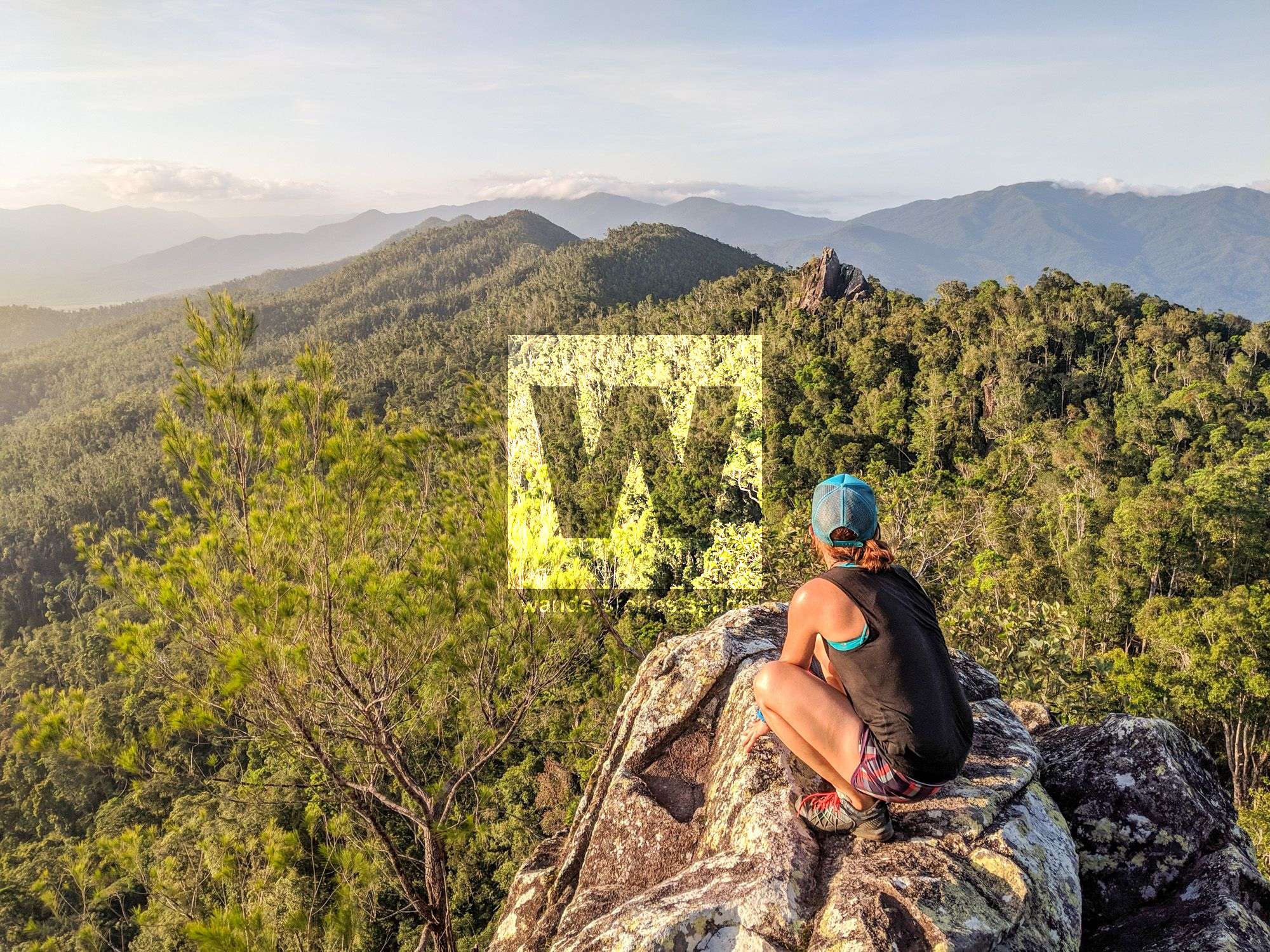
Mount Tyson rises 687 m behind the township of Tully. This well-worn track takes hikers through tropical rainforest and eucalyptus scrub, climbing up the ridgeline to the summit where they will enjoy panoramic views of Tully township and a mosaic of cane and banana farms, the coastline and islands.


Location - Tully, Far North Queensland, Australia
Distance - 5 km return
Time - 2 - 3.5 hours return
Grade - 4
Mount Tyson rises 687 m behind the town. This well-worn track takes hikers through tropical rainforest and eucalyptus scrub, climbing up the ridgeline to the summit where they will enjoy panoramic views of Tully township, Mount Mackay, Tully Gorge National Park, the Cassowary Coast, islands, and a mosaic of cane and banana farms.
See also Mount Mackay.
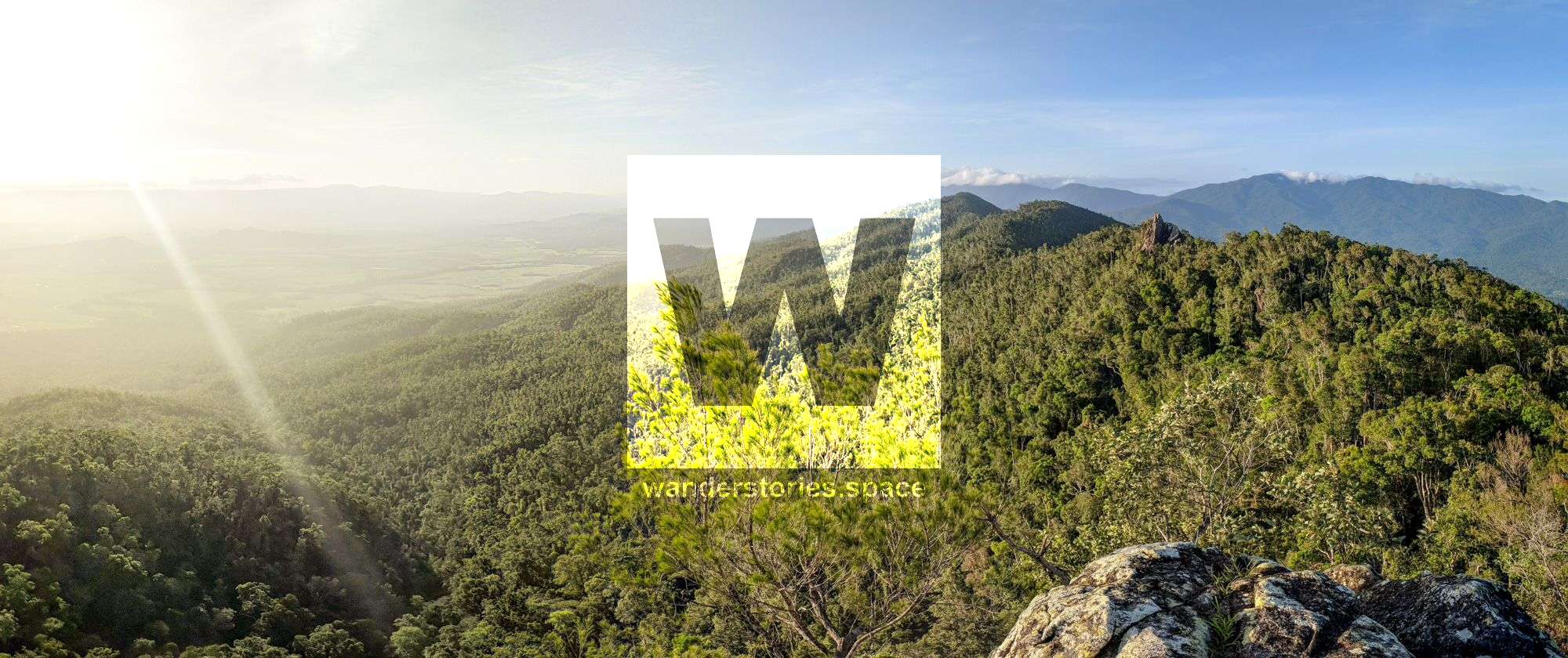
A steep climb up the rough track brings you to the first good view. "Scouts Rock", as known as "Flat Rock", is at 570 m elevation comes up after around 45 minutes. This vantage point provides a lookout over Tully and the surrounding district. The "summit" comes up in another 15 minutes where the trail ends with great views over the pinnacle. It is a reasonably strenuous walk but on a clear day, both vantage points make the hike worthwhile.
The trail continues along the ridgeline to the pinnacle and beyond however, the track becomes very rough and hard to follow. It is not recommended to continue for casual walkers summiting Mount Tyson.

Interactive Map
See also the Queensland National Parks map.
What to take
- 1-3 litres of water per person (no water on trail)
- Snacks for the top
- Camera
- Reliable footwear
- First Aid Kit and PLB
Notes
Access to the walking track is from the council park at the end of Brannigan Street near the large water tank. The is difficult to walk and takes up to three hours. It is recommended for experienced hikers with a reasonable level of fitness.
Walkers are advised to register their walk plans at the Butler Street supermarket and to remove their names upon return. The board is checked at 6 pm to ensure that all walkers have returned. Take care at the lookout and around steep slopes. This is cassowary territory which is potentially dangerous. Beware of stinging trees - large, heart-shaped leaves which result in a very painful sting when touched.
There is no water available on this trail. The track is washed out in places. It's a mix of rainforest and eucalypt woodland featuring plenty of mozzies and leeches after rainfall. It's a muddy and slippery climb after rain, which is commonplace for Tully. The entire trail has reception with Telstra.
The granite slopes of Mount Tyson are steep, with exposed rhyolite on the ridge crests. Rainforest with bull oak Cardwellia sublimis, rusty laurel Cryptocarya mackinnoniana and brown silky oak Darlingia darliniga occur on the deeper soils of the lower slopes and valleys. Patches of black she-oak Allocasuarina littoralis and pink bloodwood Corymbia intermedia woodland dominate the exposed ridges, with brush box Lophostemon confertus thickets growing in areas of shallow soil. At higher elevations, stunted and wind-sheared vegetation includes heath species like grass tree Xanthorrhoea johnsonii, grasses Gahnia spp. and scrambling coral fern Dicranopteris linearis.
This article, and all other articles, are for entertainment purposes only and are not to be used as a guide. Please see our Disclaimer for more information.