Routeburn Track - New Zealand's great walk
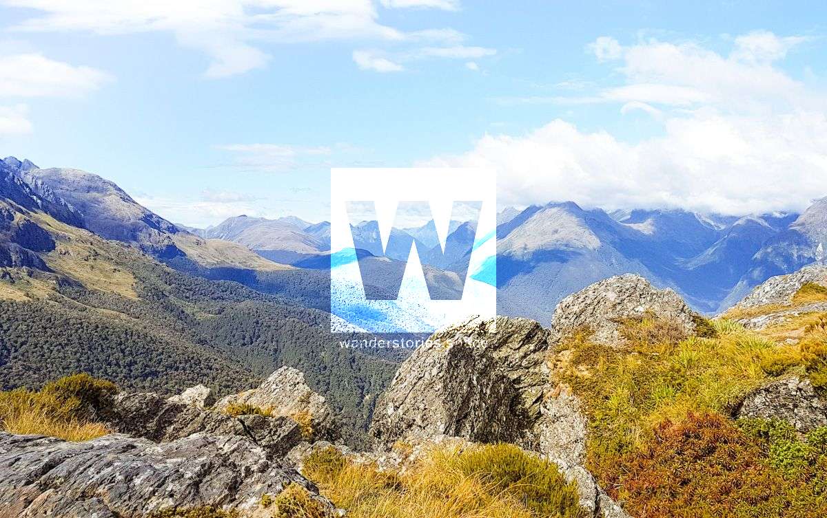
The Routeburn Track is a popular great walk with an alpine adventure experience. The track weave through meadows, glassy ponds surrounded by alpine vegetation, and over a mountain pass where you will be rewarded with spectacular vistas over vast mountain ranges and valleys.

Location - Milford Road, South Island, New Zealand
Distance - 32 km one way (not including side trips)
Time - This walk usually takes people 2-4 days, though my sister and I did it in 8 hours easily with breaks. The record for the Routeburn Classic is 2:37:51.
Difficulty - 4/5, intermediate
The Routeburn Track is a popular great walk with an alpine adventure experience. The track weave through meadows, glassy ponds surrounded by alpine vegetation, and over a mountain pass where you will be rewarded with grand views over vast mountain ranges and valleys. Wind through the Routeburn gorge along the crystal-clear Route Burn River.
When you think of the Milford Sound in New Zealand's South Island, you automatically recall guidebooks telling you to jump on a boat and cruise by the incredible cascading waterfalls fuelled by melting snow. With soaring mountain peaks, huge valleys, waterfalls and jewel-like lakes, this track links the Mount Aspiring National Park with Fiordland National Park. It's a magnificent alpine adventure.
Great Walk tracks are of a higher standard than most other tracks so are well formed and easy to follow. The tracks are usually quite wide depending on the terrain; some fit two people walking side by side in flatter areas. The surface is usually gravel, rock or dirt, and like any track can get slippery in wet weather. Most rivers and waterways on these tracks have sturdy bridges. Occasionally there are also small streams that cross the track but are usually easy enough to step across safely. Be aware that in wet weather rivers can rise very quickly and flood the tracks. There are hill climbs where the track becomes steeper, which is all the better for views. The Routeburn Track is 32 km one way, takes approximately 3 days and has a few side trips.
While the Routeburn Track may be a shorter multi-day hike, it has some of the best scenery. With soaring mountain peaks, huge valleys, waterfalls and jewel-like lakes. The highest point of the track is 1,255 metres above sea level.
The part of New Zealand that the Routeburn Track winds through has been shaped by successive glaciations into fiords, rocky coasts, towering cliffs, lakes and waterfalls. Birdlife is prolific through forested sections of the track; native tomtits, robins, fantails, wood pigeons and bellbirds are commonly seen, as well as the cheeky Kea, the world's only alpine parrot.
This is not a loop track and can be walked in either direction; one track end is at The Divide (closer to Te Anau) and the other is at the Routeburn Shelter (near Glenorchy). It is recommended that this track is avoided between May - September, when there is high risk of avalanches.
Highlights
- Spectacular panoramic views from Key Summit.
- Take in sweeping mountain views of the Hollyford valley and Darren Mountains.
- Beautiful waterfalls, one being Earland Falls which is 174 meters high.
- Crystal clear rivers
- Alpine meadows
- Winding valleys
- Unpredictable and ever changing weather
- Native bush
- A different side of the Milford Sound
How to get there
You can do this track from either side, Routeburn Shelter (Glenorchy) or The Divide (Milford Highway). There are multiple bus options servicing either end of the Routeburn Track.
My sister and I did a bag drop with our overnighter gear at the Glenorchy YHA the day before we started the Routeburn at The Divide. Then the next day we did the Routeburn Track in less than 8 hours sleeping the night in Glenorchy. The next day we hike the Cables Track back to The Divide where we parked out car. It is also possible to run the entire circuit (Routeburn and back along Cables or Green Stone) in one day for the ultramarathon runner.
Interactive Map
The journey
From West to East, starting the trip from The Divide.
Drive to The Divide car park (the start/end of the Routeburn Track). The Divide car park is about 85 km along the Milford Road from Te Anau towards the Milford Sound (1.5 hours drive).
Day 1 - The Divide to Lake Mackenzie Hut (12km / 4-5.5 hours)
From The Divide (532 m), the track climbs steadily through silver beech forest. You will come to a point in the track where you can either head up towards Key Summit as a side trip, or continue towards Lake Howden hut. Key Summit provides panoramic views over the Humboldt and Darran Mountains.
The track then continues on a gradual decline to the Lake Howden Hut (683 m). At Lake Howden Hut, the track forks off to the Greenstone Cables Track and another track off to the Hollyford Road called Pass Creek Track. Continue onto the spectacular Earland Falls (174 m) with Lake Roberts hidden above the falls. The track then winds through grassy flats dotted with trees before arriving at Lake Mackenzie (889 m).
Day 2 - Lake Mackenzie Hut to Routeburn Falls Hut (11.3km / 4.5-6 hours)
The track then traverses up the Hollyford Valley where Lake McKenzie becomes visible from above. Rest a little at the top and take in the stunning beautiful views of the mountain ranges before traversing along the exposed Hollyford Face. Just before arriving at the shelter on Harris Saddle / Tarahaka Whakatipu (1,255 m), you will notice a very steep side track down to Hollyford Road. This track is called Deadmans Track for obvious reasons.
When at the emergency shelter, be sure you take a left and head up Conical Hill (1,515 m) for the spectacular views. The saddle has many other pretty little tarns hidden in its folds. From the top of the saddle, you're surrounded by mountains - the Darren Range, Mount Madeline (2,537 m) and Mount Tutoko (2,746 m), just to mention a few. Harris Saddle (1,255 m) is the highest point of the track and is worth every step. The beautiful Lake Harris (1,225 m) greets you with waters that will be either deep blue or slate grey, depending on the weather. From the outlet of the river at Lake Harris, you will now have great views of the Routeburn Valley.
Day 3 - Routeburn Falls Hut - Routeburn Shelter (8.8km / 2.5 – 4 hours)
From Routeburn Falls Hut and after enjoying the huge views of the valley below, continue downhill crossing two swing bridges. The track descends steadily through more beech forest where you cross the open, grassy flats and a second swing bridge. The hike between the falls and the flats is only 2.3km but you lose about 300m of elevation. The Routeburn North Branch Track starts at the Routeburn Flats hut.
From here it's an easy stroll with rolling hills as you follow the Routeburn River down the valley. Meander through beautiful beech forest before sidling below the Routeburn Gorge. Just before you get to the end of the track, you will notice the Sugarloaf Pass Track on your left. Ending in the choice of doing the Routeburn Nature Walk (slightly longer). Cross the last swing bridge to where the track ends and the carpark awaits.
Side trips
Key Summit (918 m)
Time - 1 to 1 hr 30 min return
Distance - 3.4 km return via same track
This popular walk climbs above the bushline to an alpine wetland and, in good weather, offers magnificent views of the Darran Mountains and the Hollyford valley. A self-guided alpine nature walk passes a range of native vegetation: beech forest, subalpine shrublands and alpine tarnsand bogs. Birdlife is prolific and tomtits, robins, New Zealand pigeons/kererū and bellbirds/korimako are commonly seen.
It is well worth it for panoramic views of snow-capped mountains and the alpine Lake Marian. After taking it all in, start the easy descent back to The Devide car park or continue along the Routeburn Track.
Day trip to Earland Falls from The Divide
Distance - 7.5 km return via same track / 984 m elevation
Not technically a side trip but you can walk from The Divide to these majestic forest falls and then back to the car at The Divide.
Split Rock
This track takes you along the side of Lake Mackenzie and past the Lake Mackenzie Campsite to Split Rock.
Conical Hill (1,515 m)
Time - 1 hr 30 min – 2 hr return
A short, steep climb from the Harris Saddle up Conical Hill gives superb views of the Hollyford Valley through to Lake McKerrow and beyond to Martins Bay and the Tasman Sea. Be aware that snow and ice can sometimes make this trip hazardous early and late into the Great Walks season.
Well worth the effort!
Weather
The weather just does what it wants. Check with the Fiordland National Park Visitor Centre for up-to-date track information and weather conditions before starting, whatever the season. Flood and avalanche risks exist.
Even without a view of the snow-capped mountains, the scenery on this part of the Routeburn Track is amazing. The reflective tarns and alpine meadows are still beautiful to look upon even in the rain, mist or cloud.
Essential Gear
Good quality wet weather gear
Jumper/jacket (it gets cold at the top)
Multi-day hiking items
Sun protection (sunscreen, hat)
Water 3L
Insect repellent
Camera
Activities
Photography
Hiking
Swimming
Bird watching
Meditation & Yoga
Skill Level
Beginner - The Department of Conservation New Zealand grades the Routeburn Track as an Intermediate track. As long as you're prepared for the weather and have a bit of fitness about you, you'll be right.
Accommodation
There are four public huts and two campsites on the track (run by the Department of Conservation). The Department of Conservation (DOC) huts are equipped with mattresses, flushing toilets, running water, cooking facilities with fuel and a conservation ranger. During off peak season (May to September), fuel, running water and rangers are not present. Reservations are required for all huts and campsites. You can buy hut tickets and make reservations at DOC visitor centres nationwide, or through their online booking service. Most hikers take 3 days, 2 nights usually staying at Lake Mackenzie and Routeburn Falls huts. The trip can be extended by also staying at the other huts and made into a circuit by linking with the Greenstone and Caples Tracks, which starts and finishes near the Routeburn Shelter.
In season (24 October 2017 - 30 April 2018) bookings are required for huts and campsites.
Out of season (1 May 2018 - 23 October 2018) bookings are not required - huts and campsites are first come, first served.
Documents
Routeburn Track brochure (PDF, 8,942K) - includes map and profile
This article, and all other articles, are for entertainment purposes only and are not to be used as a guide. Please see our Disclaimer for more information.