The Link Track: Godwin's Peak, Mount Halifax, and the PRB Track
This area is certainly a magical part of North Queensland. It's a strenuous walk and you'll need to be fit to climb up some steep hill sections. The bush track is rough and uneven underfoot.

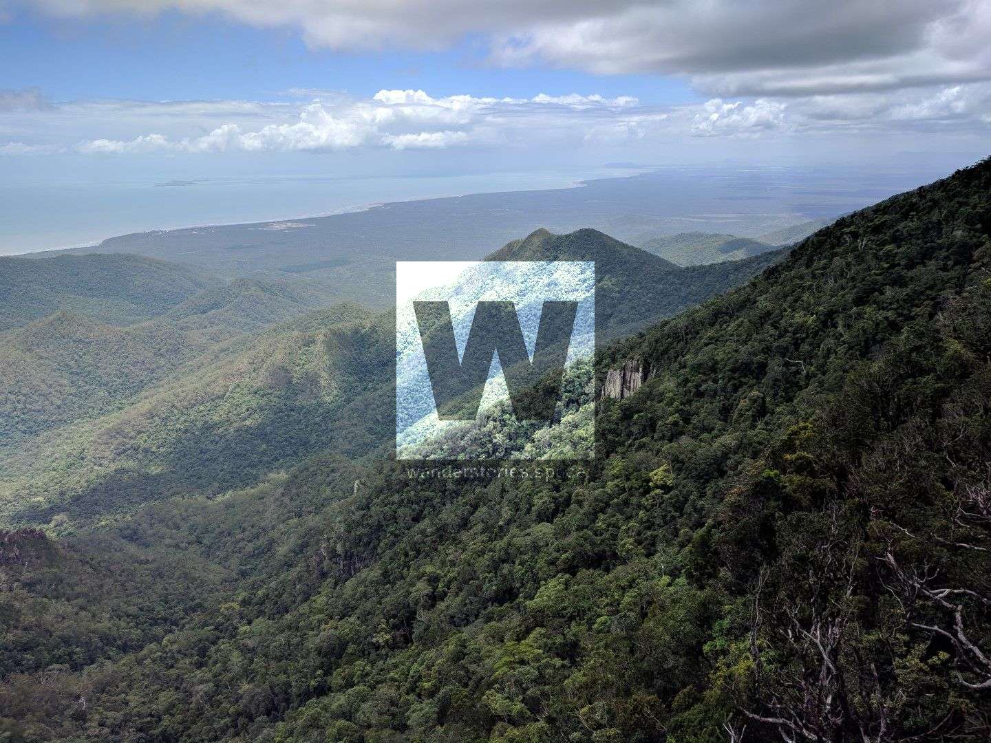
Location: Paluma Range National Park, Queensland; Mount Halifax area, south east of Paluma Township
Distance: Depending on route taken
Time: Depending on route, fitness, and breaks
Grade: 5, very difficult and strenuous
Type: On-track bushwalking
This track is certainly a magical part of North Queensland and links Mt Halifax, Godwin's Peak, and the PRB Track together. It is a strenuous walk and you'll need to be fit to climb up some steep sections (regardless of how you approach it). The bush track is rough and uneven underfoot. It is generally well-marked, but sometimes it may not be a defined track or in the creek rock hopping. Consider taking secateurs to cut you way through sections where trees have fallen over and vines (don't do this within National Park).
There are several possibilities of routes but one good use of this link track is to walk up Mt Halifax and then down via Godwin's Peak via the water source. You may also consider going across to the PRB Track and out via Bluewater. You should allow time to navigation the difficult terrain and very rough track in places.
Highlights of the walk
- Views from the summits
- Roli Falls
- And/or the PRB Track
Interactive map
Here's an interactive map of the area:
Route details from Godwin's Peak to Mt Halifax
Read the Godwin's Peak article for the details on how to summit this peak.
From Godwin's Peak, head back down into the saddle and continue onto the Godwin's Twin Peak. Then descend down the other side on the peak into a saddle. That's the easy part! Now you will make your way up the steep slopes and onto the fairly flat range. Along the top you will cross Bypass Creek and Cross Creek. Around this area is a hidden 20 metre drop off, so stick to the marked track.
The track is rough cut and marked. Follow the track to the Roli Creek water source near Mt Halifax. The last 1 km to the water point is well-marked. It is pretty steep and thick coming up to the 1,100 metre ridge after crossing the saddle between Godwin's Peak and Mt Halifax. From the Mt Halifax end the first 700 metre is well-marked as it goes to a reliable water point 130 metres down from the junction. This is nicknamed "Dave's Spring". From here, you can continue on the rough route to the PRB Track.
You will have to carry about two litres of water to get up to the saddle and onto the Mt Halifax water point. Animals may have removed a lot of the tape makers.
Some sections very thick and may be easy to lose rough cleared track.
It's not far now to the recommended camping area. It's right next to the water source shown on map. You will pass through beautiful vegetation and moss covered rocks. The suggested camping area is not too far from the water source and can accommodate a couple of tents and a few hammocks.
From the water source, you can continue across to the PRB Track or to Mt Halifax. Read the Mount Halifax article for it's section of the track.
Notes
Much of the bushwalk at lower altitudes is in, or alongside, a rocky and boulder-strewn jungle creek. Along the way there are some small gorges, waterfalls and cascades. Note: around October there is no flowing water in the creek.
There are diverse vegetation variations along the walk as the altitude changes; from woodland to rainforest, then she-oak and grass trees, to bottlebrush on exposed ridges, and then rainforest at the top. As the track ascends you climb narrow rocky ridgelines to reach the rainforest near the summit.
Some sections of the trail have a loose surfaces with ropes in place to assist you clamber up or down very steep sections of the trail. The challenge of conquering these high and dominant summits is very rewarding with the great views from all directions. There's a huge variety of the walk environment, and it's fantastic being able to enjoy and experience this special environment. Surprisingly, not many people know about this place.
The drier months of the year are the best time to go. Otherwise there will be wet slippery rocks to deal with. After heavy rain some of the creeks would be challenging to cross.
After your hike, make sure you check yourself and your partner for ticks and leeches. Be also cautious of snakes when walking; learn how to handle a snake bite and carry compression bandages.
What to bring?
You need to be self-sufficient in remote area rugged terrain hiking for the day. Ensure you have a map and compass (or GPS), and safety & communications devices like a first aid kit and PLB (or EPIRB). Carry adequate water for the whole day or refill in the creeks and sterilise. If the summit is clouded in it can be wet and cold up top, even in summer, so take a raincoat and jumper.
Depending on time of year, water resupply may be unreliable and you may need to carry water for the day. At Camp 1 (510m altitude), there is a water point at Bridal Falls which may not be flowing well (In October 2015 there was a small trickle down the rockface).
Brief History
The Bluewater Forestry Rd to Mt Halifax track has not been maintained since Aug 2010. Once The PRB track is recut, it will be an easy to get to Circle View mountain via Three Ways. However from Tube Corner to Three Ways will need a lot of clearing to get through.
Dave Dunk and Trev and Stan were the main team that did most of the Mt Halifax track in 2008/6. Glen helped with the last bit from Camp 3 to Mt Halifax. You will see signs with "Glen's Way" and "Dave's Way" to mark which part of the track they cleared. Trev and Mickle have been making other tracks in the area since then, the first was the Paluma Bluewater Rollingstone track which we completed late 2009 and 3 others in the inaugural Paluma to Mt Halifax walk in May 2010. They marked a track from Tube down to Ollera then rock hopped to the falls.
The Mt Halifax walk is also the Kokoda Challenge Track it is a one-off test after all other training. It can be broken down into sections e.g Camp 1 return. There is water you can hear it from this camp. From Camp Water up to Mt Halli is a good wide well marked you may have picked up some old markers on fallen trees but from Camp water they cannot be seen. We have to clear properly and mark to Godwins Peak from Halli.
The Forestry Track we have not been there for a long while and maybe a little overgrown. In time a run from Bluewater to Paluma or Over Halli to Paces or start there. This is big plus getting the Army to assist as well. These are the best tracks around Townsville.
The first generation markers have all been replaced with illumination markers so can be seen at night. A torch is a must for all tekkers.
Adrian Garnett and other trail runners have recut the track link the PRB Track in 2020 and it has been ran several times since.
This article, and all other articles, are for entertainment purposes only and are not to be used as a guide. Please see our Disclaimer for more information.