What to do in Cardwell
The Cardwell State Forest is home to a few sights that are often visited by tourists. These include Cardwell Spa Pools, Dead Horse Creek, Attie Creek Falls, Cardwell Lookout, and more!

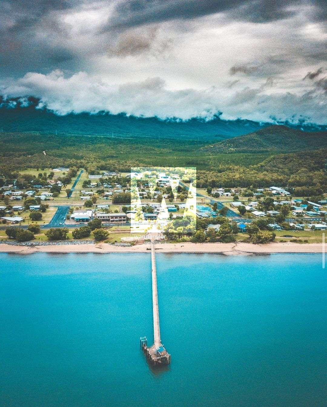
Location: Cardwell, Far North Queensland, Australia
Cardwell is a coastal town in the Cassowary Coast Region of Far North Queensland. If you're travelling the east coast, you'll pass by this town.
The Cardwell State Forest is located on the edge of Girringun National Park, Cardwell State Forest offers a combination of natural beauty, cultural significance, and forestry values. It is home to a few creeks that are often visited by tourists.
This road belonged to our Girramay ancestors' The Traditional Owners of this land, the Girramay people, have a long-standing relationship with this area. The Girramay people welcome you to their country and ask that you respect their special place.
The Girramay people historically camped alongside creeks the area, like Dead Horse Creek. They often camped near water so they could have access to drinking water and a place to cool off.
This area forms part of the 'Girroo Gurrll' creation story, known as the first surveyor to local, Girramay Aboriginal people. Girroo Gurrll rose out of the ocean near Hinchinbrook Island, part man, mostly eel and gazed around the newly made countryside. He pronounced his name loudly, then plunged into the sea and came out on top of the mountain at the back of Cardwell. He saw a freshwater lake surrounded by mangroves and he called it Girringun Lake.
Explore Cardwell Forest Drive to discover wonderful views and idyllic waterholes. Start your journey by venturing up to Cardwell lookout for panoramic views over Rockingham Bay and Cardwell Township. Continue the drive, to discover a selection of swimming and picnic areas. For the more adventurous, take a bushwalk and explore the native bushland at Cardwell lookout or Attie Creek. Each location on the drive has its own unique landscape and features-make sure you allow enough time to visit each one. Follow the Cardwell Forest Drive along to some of the places below:
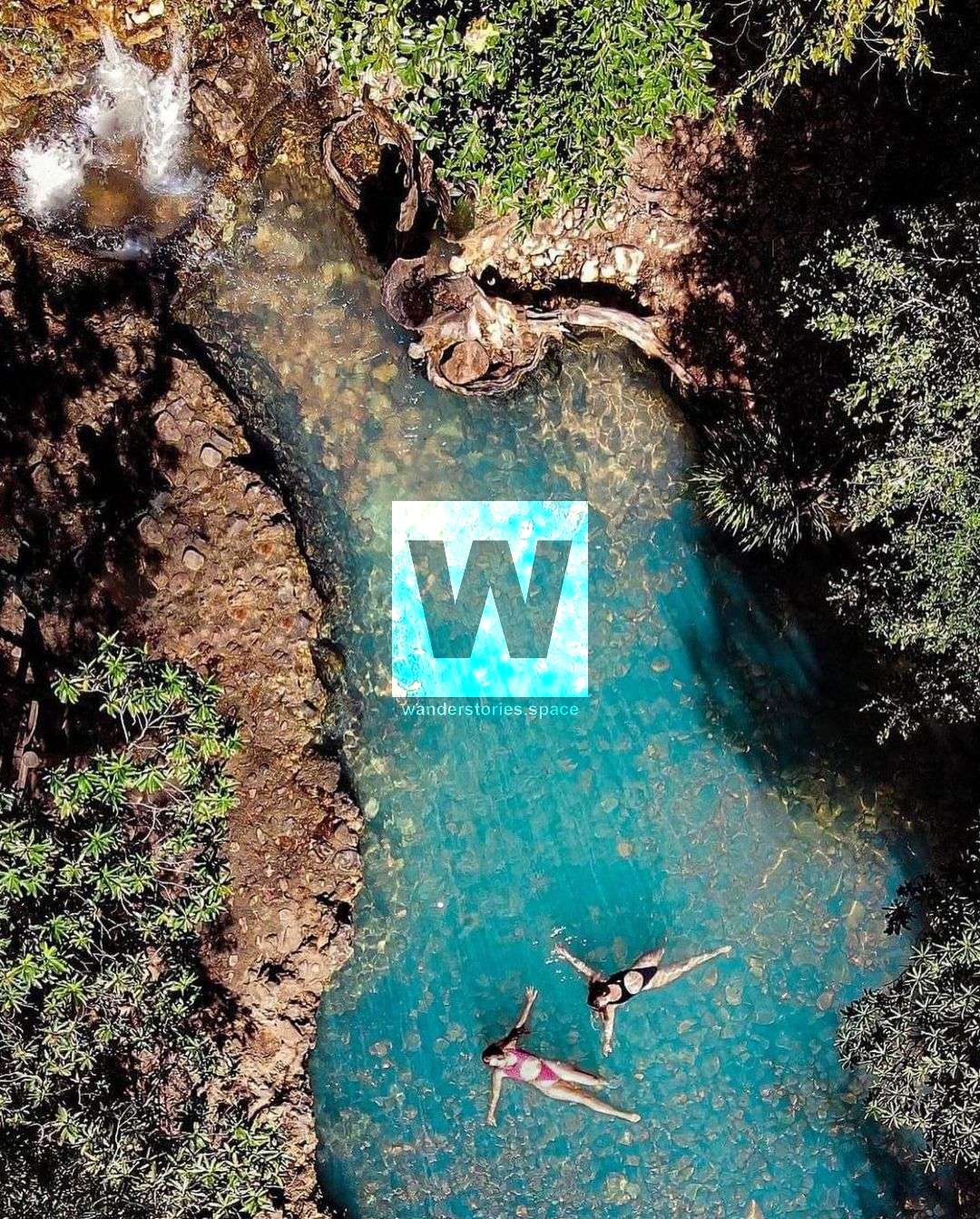
Cardwell Spa Pools
Located in Scrubby Creek, this swimming hole is mostly natural with some concrete building up the spa pool. The creek that flows through the Spa Pool relies solely on rainfall in order for it to flow and during the dry season, the water flow can slow right down and even stop completely. Scientists believe that the turquoise blue water is caused by three natural processes interacting together in the water:
- Microscopic plants (phytoplankton) in the water using dissolved bicarbonates for photosynthesis produce insoluble carbonate minerals as a by-product.
- These carbonates bind to tiny clay particles suspended in the water column, causing them to become coated in more reflective and shiny minerals such as calcite and aragonite; this composite material is known as 'marl'.
- Marl not only reflects light, but it also refracts it-causing colour changes (the same process by which water droplets create a rainbow when light passes through them). Light-reflecting and refracting from the marl, in combination with the colour of the phytoplankton, is thought to be what gives the water its distinctive colouration. This is a completely natural process and conditions must be just right to witness the stunning turquoise blue water here.
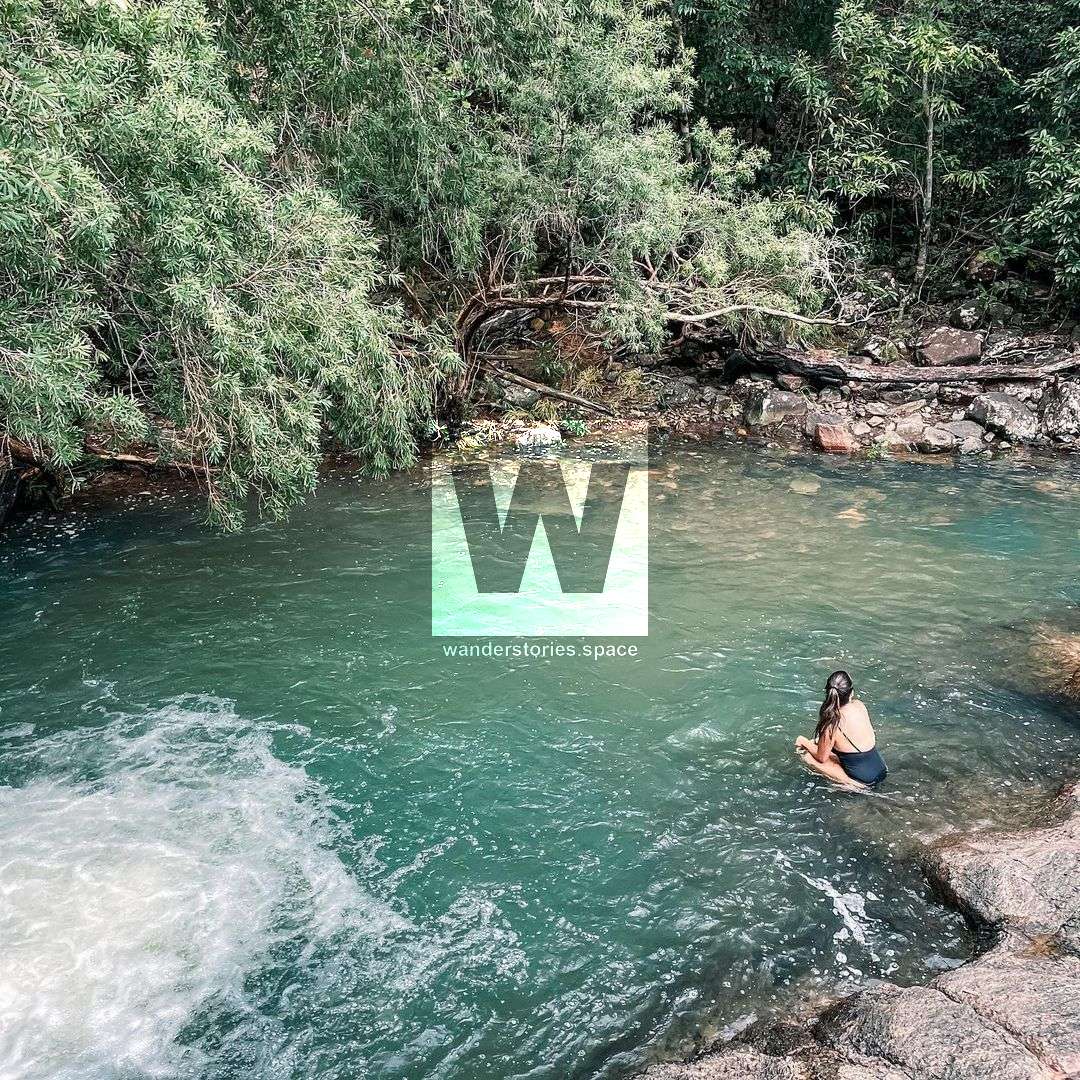
Dead Horse Creek
Another place with a small cascade and a great swimming pool. Venture down to the creek and cool off in Mother Nature's water-worn pools and waterholes. Remember to have a look around at the impressive backdrop that Cardwell Range provides. An assortment of bottlebrushes, swamp mahoganies, and rainforest pendas intersperse themselves along the creek banks, providing perfect habitats for native birds and insects. Be on the lookout for the colourful dragonflies and butterflies flitting around the cascading water. The Girramay language name for dragonfly is 'Idinjilla'.
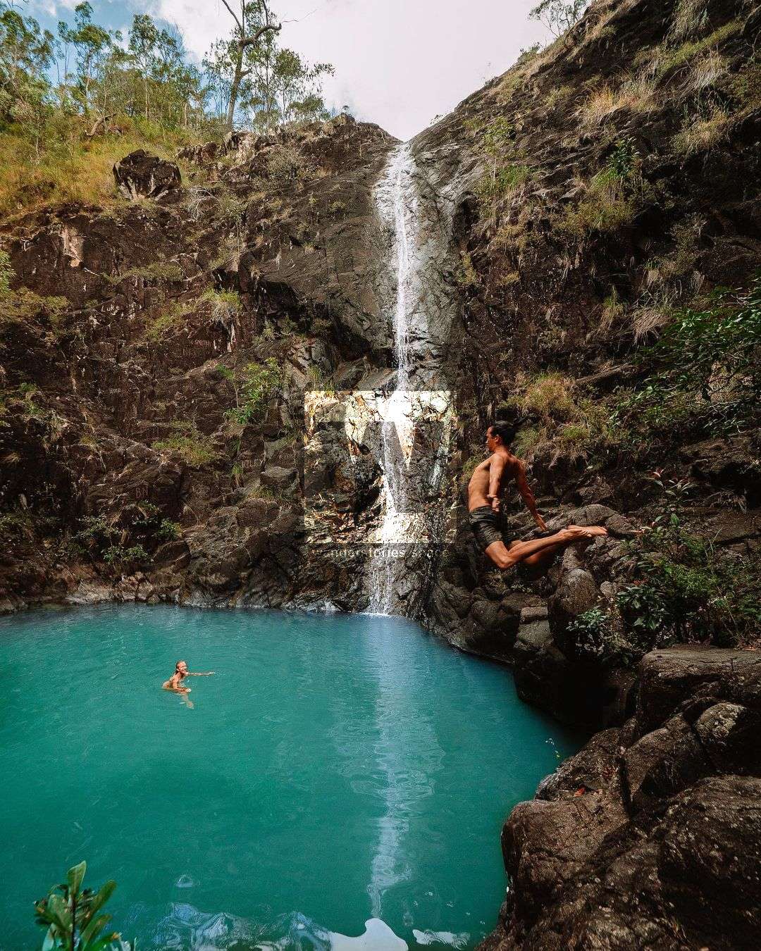
Attie Creek Falls
These falls are a short, uphill, 700-metre walk one-way and provide for a great place for a dip. From the car park and picnic area, a leisurely 100m walk will take you down to lower Attle Creek where you can enjoy small, cascading waterholes. Enjoy picturesque views of Rockingham Bay as you venture up the rocky gorge to Attie Creek Falls. Attie Creek is a prime example of dissimilar vegetation types growing and surviving together, a unique feature of the Cardwell region. Look around for the locally uncommon, Gymple messmate trees Eucalypytus cloeziana, easily spotted by their tall, branchless trunk and flaky grey-brown bark. When in flower these trees have beautiful lemon blossoms. Ancient cycad trees Cycas media, known by the local Geramay people as Gajira' can be spotted in this area. These poisonous fruits from Gajira needed to be treated before the Giramay people ate them.
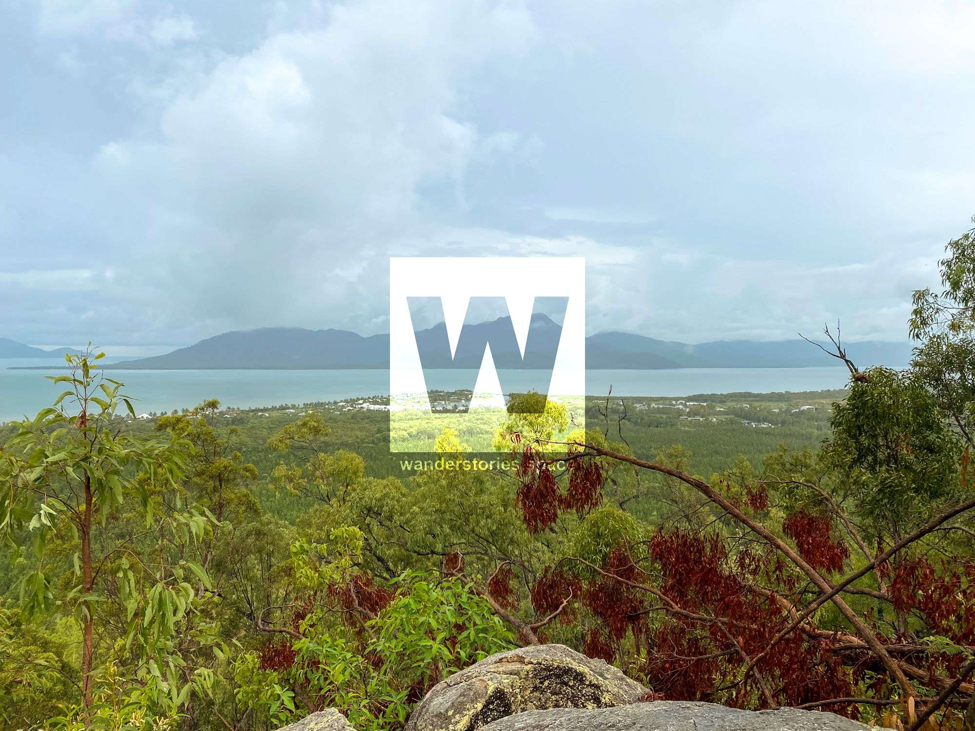
Cardwell Lookout
There are several lookouts here that provide you with many different vantage points of views over the state forest and out to the ocean. This impressive view over Rockingham Bay and the Coral Sea shows the coastal islands and surrounding townships. The green patchwork appearance of cultivated pine plantations and native forests, reflect the varying vegetation types found in the Cardwell region. 'Wabu' (meaning, native forests in Girramay language) are a blend of woodland and rainforest species.
Approximately 2,500 hectares of Caribbean pines Pinus caribaea, are grown in the Cardwell State Forest.
Interactive Map
Other points of interest that are close by are:
Inland - Kirramara Range
Tucker's Lookout
Tucker's Lookout is named after George William Tucker, a well-known and experienced surveyor in the 1930's. Tucker and T Hein lead the survey to plan the road route they spent many months camping and traversing steep slopes from the base camp in the Kennedy Valley. The steep and mountainous terrain high rainfall and abundance of streams presented many major engineering obstacles.
Below the Kennedy Valley once stood a Eucalyptus and Melaleuca woodland with extensive grasslands and wetland areas. Today, you see a mosaic of pine plantation and aquaculture production land cultivated for sugarcane, cattle, and banana and in the distance to the north lies Edmund Kennedy section of Girramay National Park. Further to the east, you can see where two of the world's most iconic and diverse world heritage areas meet the Great Barrier Reef and the Wet Tropics World Heritage Areas. Offshore, across Rockingham Bay, the rugged and profile can be seen to the south. Goold and the smaller Garden Island lie to the north. Beyond in the distance, lies the shimmering expanse of the Coral Sea and the Great Barrier Reef World Heritage Area and the Coral Sea.
Murray Valley Lookout
Murray Valley is a rich ecological ord cultural landscape. Below this lookout, the Murray River flows over this picturesque Murray Falls to the valley floor.
Kennedy Falls
Kennedy Falls is located in the Kirrama Range and is a short walk. These falls drop off the range and provide a picturesque infinity pool.
Kirrama Range Society Flats Rainforest walk
The historic timber settlement of Society Flats from the 1930s-40s marks the top of the Kirrama Range. This former timber settlement has unlogged sections with an easy 730m rainforest circuit walk. This walk allows visitors to admire some of the giant kauri pines and rose gum trees that are features of the forest. It meanders through an old 'beauty spot', an area left unlogged because of its environmental and aesthetic significance.
Blencoe Falls
Blencoe Falls is a segmented waterfall and offer's a great place to camp along Blencoe Creek.
Herbert River Falls
This waterfall is accessible via Goshen Station or by a short walk via Princess Hills
North
The Girramay Aboriginal people are the traditional custodians of this lush tropical country. Their tracks criss-cross the range valleys providing access to seasonal food and resources.
Murray Falls
Just north along the highway is Murray Falls, a cascading waterfall on the Murray River.
South
The Bandjin, Warrgamaygan, Girramay and Nywaigi Aboriginal peoples are the Traditional Owners of the country around you. The mountains, channel and coastline form natural boundaries between our traditional lands. Several landscape features in this view are of spiritual significance to our people.
Five Mile Creek
Five Mile Creek offers a spectacular clear water swimming hole and is located 7 km south of Cardwell.
Hinchinbrook Channel Lookout & Panjoo Lookout
Located at the Cardwell Gap. These are some of the best views you can find around here.
Dalrymple Gap Track
The Dalrymple Gap walking track takes you across the heritage-listed road bridge that was built from 1864 to 1865.
Notes
- The creeks and waterholes throughout the drive rely on rainfall. At drier times of the year, flows may be minimal.
- Do not enter the water when the creek is flooded. Flash flooding (rapidly rising water) can occur here.
- Take care near the water. Swim with caution at waterholes, ensure children are supervised at all times.
- Do not dive or jump into the water-varied depths and submerged objects.
- Taka adequate drinking water and snacks with you.
- Stay on the track and roads. Obey all roadside safety, directional and warning signs.
- Fires are not permitted. To report a wildfire call Triple Zero (000).
- Everything in the park is protected. Please leave everything as you found it.
- Plan your journey. There is no camping, toilets or rubbish bins on the drive. The nearest toilets are on the Cardwell foreshore, in the Cardwell Township.
- Dogs must be on a leash. Dogs are not permitted in the national park section of Attie Creek. In all other areas, dogs must be on a leash at all times.
This article, and all other articles, are for entertainment purposes only and are not to be used as a guide. Please see our Disclaimer for more information.